


FARO GeoSLAM ZEB Horizon
GeoSLAM ZEB Horizon: The Ultimate Handheld LiDAR Scanner for Fast, Accurate 3D Mapping
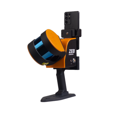
The GeoSLAM ZEB Horizon is a highly portable, handheld LiDAR scanner designed for professionals in surveying, construction, archaeology, and asset management. Combining advanced LiDAR technology with real-time 3D mapping capabilities, the ZEB Horizon is the ideal tool for outdoor and indoor scanning where accuracy, flexibility, and speed are essential. This versatile device allows you to quickly capture high-resolution 3D data in even the most difficult-to-reach areas, making it a go-to solution for professionals who need efficient, accurate, and easy-to-use scanning solutions.
Key Features:
-
Long Range & High Accuracy: The ZEB Horizon offers an impressive 100-meter range and accurate 1cm precision at 10 meters. This ensures detailed and reliable 3D data capture, making it ideal for large-scale surveys, indoor mapping, site inspections, and infrastructure scanning where high accuracy is paramount.
-
Lightweight and Ergonomic: Weighing just 4.3kg (9.5 lbs), the ZEB Horizon is incredibly lightweight and designed for easy handheld operation. Its ergonomic design ensures comfort during long scanning sessions, allowing users to carry and operate the scanner without fatigue. Its portability makes it an excellent choice for scanning in tight spaces, stairways, and challenging terrains where tripods or fixed scanning stations are not practical.
-
Rapid Scanning & Efficiency: With the ability to scan up to 43,000 points per second, the ZEB Horizon captures 3D data quickly and efficiently, significantly reducing the time spent on-site. Whether you’re scanning building interiors, outdoor environments, or complex structures, the ZEB Horizon delivers high-speed data capture for faster project turnaround.
-
Fully Integrated Solution: The ZEB Horizon is a fully integrated solution that includes both the scanner and the accompanying software. GeoSLAM Hub enables real-time data collection and processing, ensuring that you can view your results instantly and make adjustments as needed. Its integration with popular platforms such as AutoCAD, Revit, PointCab, and Trimble ensures seamless compatibility for post-processing and integration into existing workflows.
-
Flexible and Scalable: Ideal for both indoor and outdoor scanning applications, the ZEB Horizon is designed to operate in challenging environments like construction sites, heritage buildings, industrial facilities, and urban mapping projects. It can be used for single-person scanning or adapted for multi-person scanning in larger teams, allowing for scalable solutions for projects of any size.
-
Real-Time 3D Visualization: The scanner provides real-time 3D visualization of the scan as you work, offering immediate feedback to ensure data accuracy. This allows you to spot any gaps in coverage or potential errors during the scanning process, reducing the need for re-scanning and improving overall productivity.
-
Versatile Applications: The ZEB Horizon is ideal for a wide range of applications, including building surveys, facade inspections, site planning, as-built documentation, and facility management. It can be used to capture data for BIM, GIS, 3D modeling, heritage preservation, and mapping, making it an incredibly versatile tool for professionals across industries.
Why Buy the GeoSLAM ZEB Horizon Over Other Handheld LiDAR Scanners?
-
Unmatched Portability & Ease of Use: The ZEB Horizon is one of the most portable handheld LiDAR scanners on the market. Weighing only 4.3 kg and offering ergonomic handling, it is designed to be operated with ease by a single person, making it far more convenient for scanning in confined spaces or tough terrains compared to bulkier alternatives.
-
Longer Range and Superior Accuracy: With its 100-meter range and 1cm precision at 10 meters, the ZEB Horizon provides an exceptional balance of range and accuracy, surpassing many other handheld scanners in its class. This long-range capability allows you to scan larger areas and more complex environments, without sacrificing data quality.
-
Efficient, Real-Time Scanning: The ZEB Horizon’s ability to scan at a rate of up to 43,000 points per second makes it an efficient solution for capturing detailed 3D data without wasting time. You can quickly cover large areas in one pass, reducing the time spent on-site and ensuring faster project completion.
-
Versatile Use Cases: Whether you're scanning interiors, outdoor landscapes, industrial plants, or heritage sites, the ZEB Horizon is built to handle a diverse range of applications. It’s perfect for surveying, construction, heritage conservation, and asset management, giving professionals flexibility across multiple industries.
-
Seamless Integration with Leading Software: The GeoSLAM Hub software is compatible with popular 3D modeling and design platforms like AutoCAD, Revit, and PointCab, allowing you to integrate your scanned data with your existing workflow. This level of compatibility makes it easier to use the ZEB Horizon in BIM and GIS environments, ensuring streamlined project delivery.
-
Efficient Data Processing: The ZEB Horizon doesn’t just capture data—it helps you process it with GeoSLAM Hub and integrated cloud-based tools. This eliminates the need for third-party software, reduces the complexity of post-processing, and ensures quick results. With real-time visualization, you can immediately assess data quality and avoid errors that would require rework.
-
Durability for Challenging Environments: With its rugged design, the ZEB Horizon is ideal for working in outdoor environments, construction sites, and industrial spaces. It’s built to withstand dust, moisture, and the wear-and-tear associated with tough working conditions, making it a reliable choice for fieldwork.
Who Should Buy the GeoSLAM ZEB Horizon?
- Surveyors needing a lightweight, portable solution for large-scale or complex site surveys that require both indoor and outdoor scanning.
- Construction managers and architects who need a quick and accurate way to capture site data, create BIM models, or inspect buildings and facades.
- Facility managers and asset managers who want to scan facilities, track asset conditions, and update as-built models.
- Archaeologists or heritage professionals looking for a non-intrusive, efficient way to digitize historical structures, landscapes, and monuments.
- Environmental professionals and urban planners who need high-precision scans for topographic mapping or landscape modeling in urban or remote locations.
Conclusion:
The GeoSLAM ZEB Horizon stands out as a versatile, handheld LiDAR scanner with long-range, high-precision capabilities, real-time scanning, and integrated software. Its portability, speed, and ease of use make it an excellent choice for professionals across industries who require a flexible, efficient, and accurate 3D scanning solution. Whether you’re capturing data for construction, site documentation, asset management, or heritage conservation, the ZEB Horizon is designed to deliver reliable, high-quality results—every time.
Ready to elevate your 3D scanning capabilities with the GeoSLAM ZEB Horizon? Contact us now to learn more or place your order today!